
Carters
- btowne33

- Jul 11, 2021
- 4 min read
Being Goal Oriented Is Good But Sometimes Can Be Tiresome and Muddy

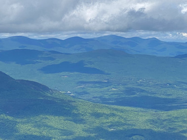
Heading away from Middle Carter looking at North Carter and Moriah
I could hit all three 4000-footer Carter peaks in a 13-mile loop which I was putting off knowing it would be a hard one. So, I rested up and ate right to at least have the right mojo. It was officially a holiday so I knew the crowds would be using this opportunity and fair weather starting at 47 degrees at 7 AM and ending in 73 by midday. It is amazing what you would wake up at 4 AM for in this life, to which I thought hiking would not make the list. Now, it’s something I really look forward to doing. The trail is so still at sunrise and starting to mist off the night's precipitation. It felt like I was shot out of at a cannon going up Carter Dome with a big pep in my step. The incline is constant but not awful, so I was able to keep a fast pace and stopped only a few times for a few breaths. I remember seeing Carter Dome from Wildcat at it looked huge up the ridge, however luckily the Carter Dome Trail was not up that section.
Last time I was on Nineteen Mile Brook Trail there was snow, and I was wearing spikes. This time the rocks and roots had a few days of rain which made this trek slippery and muddy. I made sure that every step had the right amount of foot surface to not slip. I guess I thought that the rain would have dried a bit more, but it did not. Every branch that sought sunlight over the trail rubbed up against me and making me constantly wetter and wetter. After an hour or two it was just ridiculous. You could not avoid it. The spiderwebs in the face just added to the adventure. It felt like the wilderness was baptizing me and cursing me.
Carter Dome was a wooded summit but there was a peak-a-boo view spot just before it which looked over the Presidentials covered with a small bit of wispy clouds. From there is was a retrace back a mile to a split off to Mt Hight which I added to the is trip because it had 360 degree views that was worth the extra steps. It did not disappoint. I stopped and ate some Cliff Bars and had some Gu. I also added electrolyte tablets to my water this trip so I would not get my usual dehydration headaches. Anyway, Mt Hight was great. I met a 60-year section hiker with blue hair from the south. She had run over 60 marathons and was out there through the rainy days longer than she wanted but was persistent because "her husband pissed her off" which I found really funny. She said that being goal oriented was painful to which I concurred as I was trying to make my feet from hurting. I gotta get this right as I am onto my 4th pair of insoles, second pair of hiking boots, and 4 different brands of socks. I feel like it’s the combination like a bad actor and could not be my size or the miles. If my feet didn’t hurt, then I swear I could do 30 miles. I will need to solve if I ever plan to do the Pemi Loop or the Presidential Traverse. I guess trial and error is the method for most hikers.
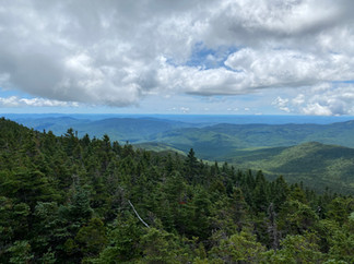
From Mt. Hight was a steep descent and then a steep ascent to South Carter to which I noted that it was no slouch. I guess there is no such thing as a 4000-footer gimme. There were no views on South Carter only a small set of stones to make a cairn, but I rested my weary bones and had a quick chat with a father daughter. The ridge walk from South the Middle Carter was magical with many wooden bog bridges to walk on. Thanks to the AMC for building these great planks, although it did not stop the onslaught of continuous muddy sections. After a while you just stop trying to walk around them and just step where you step.
When I got to Middle Carter, I was toast. A couple of ladies where taking pictures with a sign that said Middle Carter #42 and she asked me if I wanted a picture. I covered up the number 2 and victoriously put my foot on the cairn. I thanked them and said "y'all enjoy the day". The views were spectacular from Middle Carter and surprised me along the way. I stopped a few times to take some pictures and look around. I knew this would be the memory snapshot that would have sustain me for the long 5 miles back to the car.
The Imp Trail was miserable which I could not tell if it was a river or a trail. I was definitely cursing this trail at the end of a long 13-mile day. I walked the short 1/4 mile on Route 16 back to the car and then drove the 2:40 hours back home. I liked the Carters, and I was happy to get 3 4000 footers in one hike and now I am at 40 which is just baffling to me. Being goal oriented is great, but sometimes it can be tiresome and muddy.


Date
July 5th 2021
Distance
12.8 miles
Elevation Gain
4,429 feet
All Trails


Comments